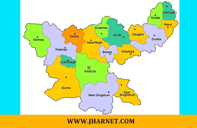
Jharkhand Districts List – झारखण्ड के जिले, उनका गठन, क्षेत्रफल एवं जनसंख्या की पूरी जानकारी एक ही जगह पर एवं झारखण्ड से जुड़ी तमाम जानकारी (G.K.) के लिए निचे दिए गए लिंक पर क्लिक करे :- Jharkhand Districts List
Cleck Here >> झारखण्ड सामान्य ज्ञान – Jharkhand GK
Jharkhand Districts List
| क्र० | जिले | गठन | क्षेत्रफल | जनसंख्या |
| 1 | Bokaro | 31/03/1991 | 2883 KM2 | 2062330 |
| 2 | Chatra | 29/05/1991 | 3718 KM2 | 1042886 |
| 3 | Deoghar | 01/06/1983 | 2477 KM2 | 1492073 |
| 4 | Dhanbad | 01/11/1956 | 2040 KM2 | 2684487 |
| 5 | Dumka | 1855 | 3761 KM2 | 1321442 |
| 6 | East Singhbhum | 16/11/1990 | 3562 KM2 | 2293919 |
| 7 | Garhwa | 01/04/1991 | 4093 KM2 | 1322784 |
| 8 | Giridih | 06/12/1972 | 4962 KM2 | 2445474 |
| 9 | Godda | 25/05/1983 | 2110 KM2 | 1313551 |
| 10 | Gumla | 28/05/1983 | 5360 KM2 | 1025213 |
| 11 | Hazaribagh | 1833 | 3555 KM2 | 1734495 |
| 12 | Jamtara | 26/04/2001 | 1811 KM2 | 791042 |
| 13 | Khunti | 12/09/2007 | 2535 KM2 | 531885 |
| 14 | Koderma | 10/04/1994 | 1494 KM2 | 716259 |
| 15 | Latehar | 04/04/2001 | 4291 KM2 | 726978 |
| 16 | Lohardaga | 1983 | 1502 KM2 | 461790 |
| 17 | Pakur | 28/01/1994 | 1806 KM2 | 900422 |
| 18 | Palamu | 1892 | 4393 KM2 | 1939869 |
| 19 | Ramgarh | 12/09/2007 | 1341 KM2 | 949443 |
| 20 | Ranchi | 1899 | 5097 KM2 | 2914253 |
| 21 | Sahibganj | 17/05/1983 | 2063 KM2 | 1150567 |
| 22 | Simdega | 30/04/2001 | 3774 KM2 | 599578 |
| 23 | West Singhbhum | 16/11/1990 | 7224 KM2 | 1502338 |
| 24 | Seraikella Kharsawan | 2001 | 2657 KM2 | 1065056 |
Cleck Here >> झारखण्ड सामान्य ज्ञान – Jharkhand GK
‘Jharkhand Districts List’ – झारखण्ड के जिले, अगर यह जानकारी आपको अच्छी लगी और झारखण्ड से सम्बंधित सारी जानकारी पाते रहना चाहते हैं। तो आप हमारे Facebook पेज को Like कर लें धन्यबाद। “Jharkhand Districts List”
Jharkhand is a state in eastern India, carved out of the southern part of Bihar on 15 November 2000. The state shares its border with the states of Bihar to the north, Uttar Pradesh to the northwest, Chhattisgarh to the west, Odisha to the south and West Bengal to the east.
